Border Land 6
McALLEN, TEXAS. Time was invented, it has been said, to keep everything from happening at once. Here, time has been forgotten twice. When it was first forgotten this was a largely agricultural area and nothing happened. Now it is post-NAFTA. Time has been forgotten again and everything is happening at once. Between Brownsville and McAllen there seems to be construction, dust, and heavy equipment wherever you turn. Within yards you can go from decrepit buildings with hand painted signs for businesses that no longer exist to brand new franchises that line the Interstate north and south of the new Sunshine Mall in Brownsville or the La Plaza Mall in McAllen.
Prosperity isn’t around the corner; it is on the corner. For the first time in years, the unemployment rate is going below 10 percent. Now there is something to do other than farm work. Now it is possible to finance a house. This is a major change.
These once sleepy places— Brownsville, McAllen, and Laredo— are now major growth centers. With population growth of 37.5 percent from 1990 to 1997, Laredo is the second fastest growing urban area in the United States.
Only Las Vegas, at 48 percent, grew faster.
McAllen, at 33.2 percent growth, is the third fastest growing. Brownsville, at 23.3 percent growth, is growing at 3 times the national average.
Numbers do not describe growth like this. You have to think about something that is moving, pulsing. You need to imagine, instead, one of those algae blooms in the oceans, those odd events where a combination of nutrients and temperature causes algae to go into reproductive overdrive and fill an entire area, crowding out everything else. That’s what you see down here. Inevitable, overpowering growth. It’s an industrial bloom that is overrunning the agriculture roots of the Rio Grande Valley and turning Laredo, always a trade oriented city, into a sprawling version of Beyond Thunderdome.
Those quick messages are confirmed by the ride from Brownsville to McAllen. Instead of taking Interstate 83 I took what some call the old military highway, route 281. It is an old two-lane road that runs closer to the Rio Grande, through farmland and small villages. It is quieter, has much less traffic of any kind, and provides a calmer window on how things are changing.
On both sides of the road, freshly tilled fields recede into the distance. They are fields of dreams. Villages— small gatherings of modest houses usually made of wood or adobe and articulated by dirt roads— hug the side of the highway. Old cars. Collections of rusting objects. Sometimes a gathering of mobile homes.
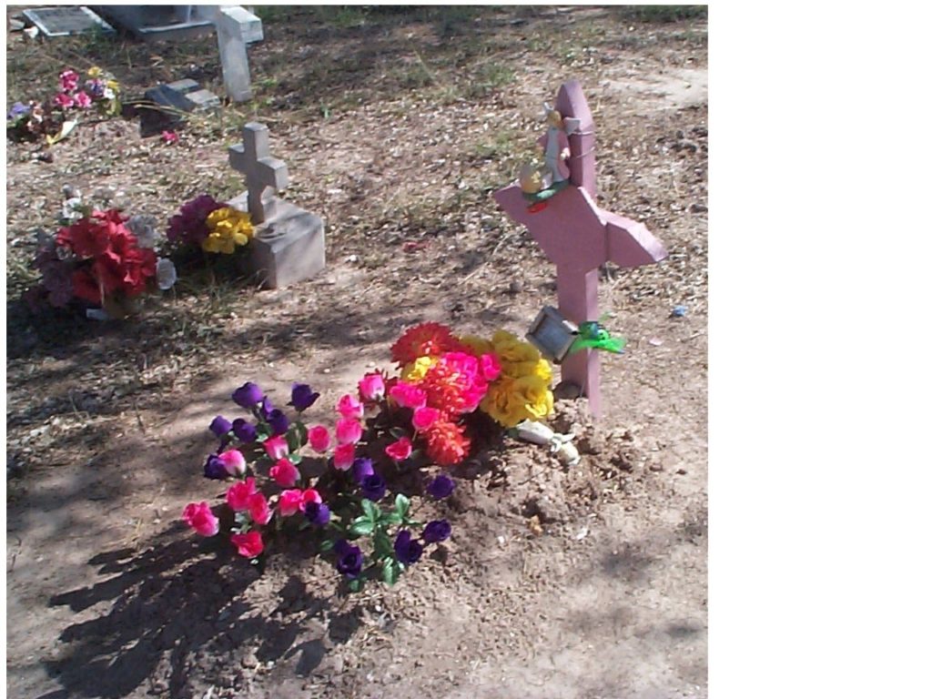
Small cemeteries are also along the road, some near villages, and some at a mysterious distance from any community. One is set like an island surrounded by an ocean of recently tilled soil. It is connected to the highway by a narrow isthmus, a pathway lined with brilliant flowers.
New housing developments— or at least offers of developments— appear here and there, usually offering an acre or so of land for something under $10,000 with $50 to $100 down. Most are signs on vacant land. Some have houses sprinkled at random. Unlike the Colonias, developments on unincorporated land that have little or nothing in the way of infrastructure, the new developments promise water and electricity. Add a manufactured home to the lot and it is possible to have a new house for less than $40,000. That price, in turn, is on target for income along most of the border. It is not difficult to imagine miles of subdivisions replacing the farmland very quickly.
I stop to examine one of the cemeteries. It is a small piece of land measuring about 40 by 50 feet and separated from the road by a low chain link fence. There is no barrier on the other three sides, which recede into a tilled field. Inside, it is a mixture of large and small stones, single plots and family plots. At the front there is a wooden marker with toys and flowers, a child’s grave. The names on the stones are Hispanic.
This should not be surprising. While less than 11 percent of our total population is Hispanic, the statistical relationship reverses along the border. Moving along the border, Brownsville is 84.4 percent Hispanic, McAllen is 87.3 percent Hispanic, and Laredo is 94.5 percent Hispanic.
The birth dates on the stones, in this particular cemetery, range back to 1870. Others, without stones, were probably born and buried at earlier times. It makes me think of my family. My paternal grandfather was born in Scotland and came to this country at the turn of the century. My maternal grandfather was born in Ireland and came to this country just before the turn of the century. Born in Massachusetts, raised in New Jersey, I have always thought of myself as 100 percent American. But the people in these fields were being born and buried here long before my forebears even thought about crossing the ocean.
Standing there I get an odd feeling about being short-changed by language, by how much we lose when we use a word like “Hispanic” because it is politically correct. It is the word to use if you are to understand the statistics kept by the United States government. (The word was, after all, a government invention to provide a classification for the many people in America with a relationship to Spanish language and culture.) It does not describe what is happening on the border.
The people in this cemetery are not from Puerto Rico. They are not from Cuba. They are Mexicans. They are Americans. They are mestizos, descendents from intermarriages of invading Spaniards and Mexican Indians. They are the children of Cortez. They were here when the Rio Grande was a bigger river. They were here before the Rio Grande was the boundary it is today. They were here before Texas, New Mexico, Arizona, and California were called states.
Whatever the future holds, their presence is here is more powerful than language and more enduring than maps.
Next: All roads lead to Crystal City
Borderland
Starting the journey: Riding into Laredo
A statistical picture of life along the border
Austin: The incredible disappearing Slacker
San Antonio: High Times and Low Water
Yturria Land and Cattle and El Canelo Ranch: Where’s the Beef?
Brownsville: Lifeguard on the Rio Grande
McAllen: Fields of dreams
All roads lead to Crystal City
Big Bend and the bridge at Presidio
Marfa: Herds of tomatoes, as far as the eye can see
Tucson: Containing growth
Tucson: Born to be wild?
Yuma and the dusty road to Mexicare
San Diego: The Ultimate Crop
Notes, mile marks and pictures
This information is distributed for education purposes, and it is not to be construed as an offer, solicitation, recommendation, or endorsement of any particular security, product, or service.
Photo: Scott Burns/ A child’s grave along highway 281 between Brownsville and McAllen
(c) A. M. Universal, 2000